In 1792 the Mountsorrel Enclosure Act formalised an already existing area of common land between the Mountsorrel North and South parishes. This land ultimately belonged to Robert Herbert Butler, 3rd Earl of Lanesborough who was a major landowner in the town. This was called “Mountsorrel Hills Common” due to it predominately being comprised of Castle Hill and the adjacent Broad Hill.
Although many streets have changed their name over the years, our street, Watling Street seems to have held onto its name for a very long period of time. Referred to within the 1792 Enclosure Act by name, it was also mentioned in a 99 year lease signed by Joseph Danvers of a house he owned on Watling Street in 1732.
In John Nichols encyclopaedic 4 volume History and Antiquities of the County of Leicester (1795>1815) he refers to the street bounding the castle and the Earl of Leicester’s land as “Barn Lane” but no other reference to this has ever been found. Maybe he confused this with “Bond Lane” which also runs along the north western edge of his holdings and adjacent to the castle?
In the following sections we’ll talk about house numbers, to be pedantic, Mountsorrel didn’t get these assigned until the early 1920s, but we’ll use the later numbers when we talk about each house to make things a bit clearer
So, why is this site called “Near The Hills”?
As you climb Watling Street and get towards the top, the street splits; to the right is the Castle View care home which was once The Poplars, the former residence of the various quarry managers through the years, and to the left is a pedestrian section which is where we are.
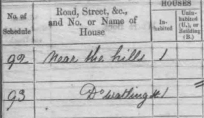
This pedestrian section was referred to as “Watling Street – Near The Hills” in the 1861 and 1871 censuses and we rather liked the name. It of course refers to the fact that this part of the street is nestled up to and in some cases is in the Mountsorrel Hills Common.
In 1816 local farmer and landowner, George Watkinson, commissioned a map of his holdings, and luckily this still exists in the Leicester Record Office. It appears to be a copy of an older (uncredited) map as it shows far more than just his properties and land as the map shows not only George Watkinson’s farms and properties but luckily all the other buildings and holdings in the surrounding area! Sadly though the book accompanying the map has been lost over time, this would have contained the key and descriptions of each plot shown.
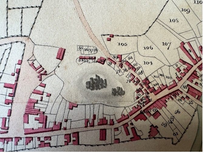
The earliest map showing our area of Watling Street in detail (houses numbered 81/82 would be ours along with the land opposite)